• Skip to primary navigation
  • Skip to main content
  • Skip to primary sidebar
  • Skip to footer

RealClimate

Climate science from climate scientists...

  • Start here
  • Model-Observation Comparisons
  • Miscellaneous Climate Graphics
  • Surface temperature graphics
You are here: Home / Archives for Stefan

Stefan

About Stefan

High-resolution ‘fingerprint’ images reveal a weakening Atlantic Ocean circulation (AMOC)

12 Oct 2025 by Stefan 17 Comments

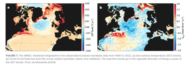
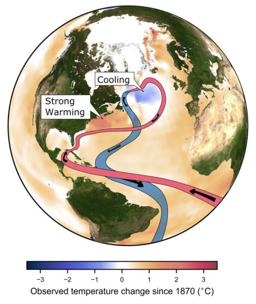
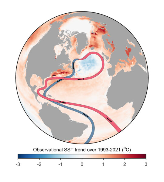
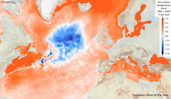
The #AMOC is the reason for Europe’s mild climate. Evidence that it is slowing has been piling up over the years – it now is likely at its weakest in at least a millennium, and it may even be approaching a tipping point. Here I will show you the latest high-resolution images – and also discuss whether there is serious evidence speaking against an ongoing AMOC weakening.

Our regular readers are well aware of the Atlantic Meridional Overturning Circulation, or AMOC in short, a large-scale overturning motion of water along the whole Atlantic which transports a quadrillion Watts (that is 1015 W) of heat to the northern Atlantic, partly via the Gulf Stream. (If you are new to the topic, check out this article.)

Instabilities of the AMOC have produced some of the most dramatic climate changes in recent Earth history, well-known to paleo-climatologists (see e.g. my by now ancient review in Nature 2002), and concerns that we are destabilizing it by causing global warming has been rising sharply in expert circles in recent years (see last year’s open letter by 44 experts).

[Read more…] about High-resolution ‘fingerprint’ images reveal a weakening Atlantic Ocean circulation (AMOC)

Filed Under: Climate Science, Featured Story, Oceans

Andean glaciers have shrunk more than ever before in the entire Holocene

19 Mar 2025 by Stefan

Glaciers are important indicators of climate change. A recent study published in the leading journal Science shows that glaciers in the tropical Andes have now retreated further than at any other time in the entire Holocene – which covers the whole history of human civilisation since the invention of agriculture. These findings are likely to resonate beyond the scientific community, as they strongly support the lawsuit filed by a Peruvian farmer against the energy company RWE, which has returned to court this week.

Paleoclimatologists can determine how long bedrock beneath a glacier has been covered by ice using measurements of specific isotopes. When rock surfaces are exposed, isotopes such as carbon-14 and beryllium-10 form due to bombardment by cosmic radiation. If, however, the rock is covered by an ice sheet, it is shielded from this radiation, and these unstable isotopes gradually disappear through radioactive decay (with half-lives of 5,700 and 1.4 million years, respectively). This method, known as cosmogenic radionuclide dating, has been well-established for decades. I first encountered it myself 23 years ago during an excursion with glacier experts to New Zealand’s Southern Alps.

The new study applied this method to examine several glaciers in the tropical Andes (see Fig. 1).

Fig. 1 Map and photos of the glaciers studied. (C) shows the Queshque Glacier, with the coloured lines indicating the massive retreat since 1962. Source: Gorin et al. 2024.

In rock samples collected at the edges of the glaciers, researchers found isotope concentrations close to zero. From this, they conclude that these rocks must have remained covered by ice throughout the entire Holocene, shielding them from cosmic radiation. This indicates that these glaciers are very likely smaller today than at any point in at least the last 11,700 years.

This finding aligns with several previous studies showing that temperatures in the tropical Andes have never been warmer during the Holocene than they are today. For instance, reconstructions of the glacier margin of the Quelccaya Ice Cap demonstrate that it has not been smaller than today at any time in at least the last 7,000 years. Temperature reconstructions based on proxy data further support this conclusion.

Global Warming Means Global Glacier Retreat

The Andes are not an exception: according to current research, global average temperatures today are very likely higher than at any other point during the entire Holocene. Given that an ice age lasted for more than 100,000 years before the Holocene, today’s temperatures are probably the highest experienced in about 120,000 years. This unprecedented warming, which began in the 19th century and has so far reached around 1.3–1.4°C, is almost entirely driven by human activity – primarily the burning of fossil fuels. According to the Intergovernmental Panel on Climate Change (IPCC), natural factors have contributed very little to recent warming, probably even having a slightly cooling effect, due to declining solar activity since the mid-20th century (a fact reflected in the title of former RWE manager Fritz Vahrenholt’s book, Die kalte Sonne – The Cold Sun).

As a result, glaciers worldwide continue to lose mass (see Figure 2). In Germany, only four glaciers remain, following the disappearance of the Southern Schneeferner glacier in September 2022. Soon, there will be no glaciers left in Germany at all.

Fig. 2 Glacier Mass Loss in Different World Regions. Source: World Glacier Monitoring Service.

Implications for the RWE Case

The RWE case addresses, among other things, whether global warming caused by CO₂ emissions is responsible for the severe glacier melt, the substantial retreat of the glacier by approximately 1.5 km over the past 140 years and the thawing of permafrost above the city of Huaraz in Peru. A 2021 attribution study published in the respected journal Nature Geoscience has already conclusively demonstrated this connection; however, RWE appears to continue challenging these findings.

In this context, the new data from Gorin et al. are particularly relevant. The Queshque Glacier, now smaller than at any other time in at least the last 11,700 years, is located only 40 km from Huaraz, in the same mountain range as Lake Palcacocha (see Fig. 3).

Fig. 3: Satellite Image Showing Huaraz (Star), Queshque Glacier, and Lake Palcacocha. Source: Google Maps.

It is highly likely that local climate changes across this area differ minimally at most. Although average climate conditions can vary over short distances due to local topography, climate warming typically has a correlation radius of more than 1,000 km. Therefore, there is no meaningful difference in climate change effects between Queshque Glacier and Lake Palcacocha.

This region is already experiencing the most significant climate warming in the history of human civilisation. It will undoubtedly continue until the global economy achieves climate neutrality, essentially, net-zero CO₂ emissions.

In the RWE trial, the central issue will be whether, and to what extent, the city of Huaraz and the plaintiff would be affected by a glacier flood. A systematic analysis of past glacial lake outburst floods (GLOFs) in the region has examined 160 such events based on satellite imagery. The findings clearly identify the Andes around Huaraz as a hotspot for this risk (see Fig. 4).

Fig. 4: Study Area of the Glacial Lake Outburst Flood (GLOF) Research.
Huaraz is located at 9.5° south latitude within the high-risk zone marked in red. Source: Emmer et al. 2022.

Additionally, this study shows that the frequency of such floods has increased significantly since 1980 (see Fig. 5). Before 1980, there was only one year with more than two recorded GLOFs: 1970 due to a severe earthquake. However, there are now repeatedly years with 3, 4 or even 5 glacial lake outbursts.

Fig. 5: Frequency of Glacial Lake Outburst Floods (GLOFs) in the Study Area (see Fig. 4) Since 1725. The study states: “there has been an apparent overall increase in GLOF incidence from 1725 to the present day.” Source: Emmer et al. 2022.

One thing is clear: given the existing research, it would be absurd to assume that the risk of a Lake Palcacocha outburst could be calculated based solely on historical data, without explicitly accounting for global warming caused by fossil fuels. Anyone who suggests that climate change is not happening in Huaraz – that there is no human fingerprint, and therefore no connection to RWE’s share of CO₂ emissions – may have their reasons for doing so. But the evidence clearly shows otherwise.

Filed Under: Climate impacts, Climate Science, Featured Story Tagged With: Andes, flood, Glacial, Huaraz, outburst, RWE

How will media report on this new AMOC study?

26 Feb 2025 by Stefan

I’ve been getting a lot of media queries about a new paper on the AMOC (Atlantic Meridional Overturning Circulation), which has just been published. In my view this large media interest is perhaps due to confusing messages conveyed in the title of the paper and in press releases about it by the journal Nature and by the Met Office. Whether intended or not, these give the impression that new model results suggest that the AMOC is more resilient than previously thought. That’s (unfortunately!) not the case.

[Read more…] about How will media report on this new AMOC study?

Filed Under: Climate Science, Featured Story, Instrumental Record, Oceans

The AMOC is slowing, it’s stable, it’s slowing, no, yes, …

26 Jan 2025 by Stefan

There’s been a bit of media whiplash on the issue of AMOC slowing lately – ranging from the AMOC being “on the brink of collapse” to it being “more stable than previously thought”. AMOC, of course, refers to the Atlantic Meridional Overturning Circulation, one of the worlds major ocean circulation systems which keeps the northern Atlantic region (including Europe) exceptionally warm for its latitude. So what is this whiplash about?

As is often the case with such media whiplash, there isn’t much scientific substance behind it, except for the usual small incremental steps in the search for improved understanding. It is rare that one single paper overthrows our thinking, though media reports unfortunately often give that impression. Real science is more like a huge jigsaw puzzle, where each new piece adds a little bit.

The latest new piece is a new reconstruction of how the AMOC has changed over the past 60 years, by Jens Terhaar and colleagues. The background to this discussion is familiar to our regular readers (else just enter ‘AMOC’ in the RealClimate search field): proper measurements of the AMOC flow are only available since 2004 in the RAPID project, thus for earlier times we need to use indirect clues. One of these is the sea surface temperature ‘finger print’ of AMOC changes as discussed in our paper Caesar et al. 2018 (Fig. 1). There we used the cold blob temperature anomaly (Nov-May) as an index for AMOC strength. Other studies have used other sea surface temperature or salinity patterns as well as paleoclimatic proxy data (e.g. sediment grain sizes), and generally found an AMOC decline since the 19th Century superimposed by some decadal variability. The new paper critices our (i.e. Caesar et al) reconstruction and suggests a new method using surface heat fluxes from reanalysis data as an indicator of AMOC strength.

Figure 1 The ‘cold blob’ and the warm stretch along the Gulf Stream path (red arrows). This ‘finger print’ of an AMOC slowdown is physically understood (Zhang 2008) and visible not just for the satellite era shown above, but also the reanalysis data (Fig. 3a below) and observed sea surface temperature trends since the year 1870 (Caesar et al. 2018). Map: Ruijian Gou.

Here’s three questions about it.

1. Does the ‘cold blob’ work well as AMOC indicator?

We had tested that in the historic runs of 15 different CMIP5 climate models in Caesar et al. 2018 (our Fig. 5) and found it works very well, except for two outlier models which were known to not produce a realistic AMOC. Now Terhaar et al. redid this test with the new CMIP6 model generation und found it works less well, i.e. the uncertainty is larger (although for future simulations where the AMOC shows a significant decline in the models, our AMOC index also works well in their analysis).

Which raises the question: which models are better for this purpose: CMIP5 or CMIP6? One might think that newer models are better – but this does not seem to be the case for CMIP6. Irrespective of the AMOC, the CMIP6 models created substantial controversy when their results came out: the climate sensitivity of a subset of ‘hot models’ was far too high, these models did not reproduce past temperature evolution well (compared to observed data), and IPCC made the unprecedented move of not presenting future projections as straightforward model average plus/minus model spread, but instead used the new concept of “assessed global warming” where models are weighted according to how well they reproduce observational data.

In the North Atlantic, the historic runs of CMIP6 models on average do not reproduce the ‘cold blob’ despite this being such a striking feature of the observational data, as shown clearly in the Summary for Policy Makers of the IPCC AR6 (see Fig. 2 below). Of the 24 CMIP6 models, a full 23 underestimate the sea surface cooling in the ‘cold blob’. And most of the CMIP6 models even show a strengthening of the AMOC in the historic period, which past studies have shown to be linked to strong aerosol forcing in many of these models (e.g. Menary et al. 2020, Robson et al. 2022). The historic Northern Hemisphere temperature evolution in the models with a strong aerosol effect “is not consistent with observations” and they “simulate the wrong sign of subpolar North Atlantic surface salinity trends”, as Robson et al. write. Thus I consider CMIP6 models as less suited to test how well the ‘cold blob’ works as AMOC indicator than the CMIP5 models.

Figure 2 Comparison of observed and simulated annual mean surface temperature change for 1°C global warming (IPCC, 2021, Figure SPM.5). The models on average do not reproduce the observed cold blob.

2. Is the new AMOC reconstruction method, based on the surface heat loss, better?

In the CMIP6 models it looks like that, and the link between AMOC heat transport and surface heat loss to the north makes physical sense. However, in the models the surface heat loss is perfectly known. In the real ocean that is not an observed quantity. It has to be taken from model simulations, the so-called reanalysis. While these simulations assimilate observational data, over most of the ocean surface these are basically sea surface temperatures, but surface heat loss depends also on air temperature, wind speed, humidity, radiation and cloud cover in complex ways, all of which are not accurately known. Therefore these surface heat loss data are much less accurate than sea surface temperature data and in my view not well suited to reconstruct the AMOC time evolution. 

That is supported by the fact that two different reanalysis data sets were used, leading to quite different AMOC reconstructions. Also the AMOC time evolution they found differs from other reconstruction methods for the same time period (see point 3 below).

And there is another issue: we’ve previously looked at ERA5 surface heat flux trend, as shown here from my article in Oceanography 2024:

Figure 3 Sea surface temperature trend (left) and surface heat flux trend (right) 1940-2022 from the ERA5 reanalysis data also used in Terhaar et al. Source: Oceanography 2024.

You see in both figures (in temperature as well as surface heat flux) the AMOC slowdown ‘fingerprint’ which includes both the ‘cold blob’ and a warming along the American coast due to a northward Gulf Stream shift, which is also a symptom of AMOC weakening. However, Terhaar et al. integrate over the whole northern Atlantic north of 26 °N so that the red area of increasing heat loss largely compensates for the blue area of decreasing heat loss. So in their analysis these two things cancel, while in the established concept of the ‘fingerprint’ (see Zhang 2008: Coherent surface-subsurface fingerprint of the Atlantic meridional overturning circulation) these two things both reinforce the evidence for an AMOC weakening.

3. How do these new reconstructions compare to others?

Here is how the Terhaar reconstructions (bottom two) compare:

Figure 4 Several AMOC reconstructions, with the RAPID measurements on top. The reconstruction by Frajka-Williams et al. 2015 used surface height data from satellite, and the Worthington et al 2021 reconstruction uses a water mass regression based on RAPID data. Graph: Levke Caesar.

The reconstruction at the bottom using a reanalysis product from Japan doesn’t resemble anything, while the blue one using the European ERA5 reanalysis at least has the 1980s minimum and early 2000s maximum in common with other data, albeit with much smaller amplitude; it is a lot smoother. Thus it also misses the strong AMOC decline 2004-2010 and subsequent partial recovery seen in the RAPID measurements as well as the Caesar and Worthington reconstructions. A main reason for the lack of significant trend in the Terhaar reconstructions further is the time interval they used; for the same time span the Caesar reconstruction also does not show an even remotely significant trend (p-value is only 0.5), so in this respect our reconstructions actually agree for the period they overlap. The fact that ours shows a significant AMOC decline is because of the stable AMOC we find during 1900-1960, which is stronger than in the following sixty years. Here our reconstruction method shows its advantage in that reliable and accurate sea surface temperature data exist so far back in time.

Hence, I do not believe that the new attempt to reconstruct the AMOC is more reliable than earlier methods based on temperature or salinity patterns, on density changes in the ‘cold blob’ region, or on various paleoclimatic proxy data, which have concluded there is a weakening. But since we don’t have direct current measurements going far enough back in time, some uncertainty about that remains. The new study however does not change my assessment of AMOC weakening in any way.

And all agree that the AMOC will weaken in response to global warming in future and that this poses a serious risk, whether this weakening has already emerged from natural variability in the limited observational data we have, or not. Hence the open letter of 44 experts presented in October at the Arctic Circle Assembly (see video of my plenary presentation there), which says:

We, the undersigned, are scientists working in the field of climate research and feel it is urgent to draw the attention of the Nordic Council of Ministers to the serious risk of a major ocean circulation change in the Atlantic. A string of scientific studies in the past few years suggests that this risk has so far been greatly underestimated. Such an ocean circulation change would have devastating and irreversible impacts especially for Nordic countries, but also for other parts of the world.

Post script

Since I’m sometimes asked about that: last year a data study by Volkov et al. revised the slowing trend of the Florida current as well as the AMOC. Contrary to ‘climate skeptics’ claims, it has no impact on our long-term estimate of ~3 Sv slowing since 1950, i.e. -0.4 Sv/decade (Caesar et al. 2018). Both the original and the revised trend estimates for the RAPID section data (see Figure) suggest the recent AMOC weakening since 2004 is steeper than the long-term trend we estimated.

Filed Under: Climate Science, Featured Story, Instrumental Record, IPCC, Model-Obs Comparisons, Oceans, Reporting on climate Tagged With: AMOC, Atlantic Meridional Overturning Circulation, CMIP5, CMIP6, North Atlantic

New study suggests the Atlantic overturning circulation AMOC “is on tipping course”

9 Feb 2024 by Stefan

A new paper was published in Science Advances today. Its title says what it is about: “Physics-based early warning signal shows that AMOC is on tipping course.” The study follows one by Danish colleagues which made headlines last July, likewise looking for early warning signals for approaching an AMOC tipping point (we discussed it here), but using rather different data and methods.

The new study by van Westen et al. is a major advance in AMOC stability science, coming from what I consider the world’s leading research hub for AMOC stability studies, in Utrecht/Holland. (Some of their contributions spanning the past 20 years are in the paper’s reference list, with authors Henk Dijkstra, René van Westen, Nanne Weber, Sybren Drijfhout and more.)

The paper results from a major computational effort, based on running a state-of-the-art climate model (the CESM model with horizontal resolution 1° for the ocean/sea ice and 2° for the atmosphere/land component) for 4,400 model years. This took 6 months to run on 1,024 cores at the Dutch national supercomputing facility, the largest system in the Netherlands in terms of high-performance computing.

It is the first systematic attempt to find the AMOC tipping point in a coupled global ocean-atmosphere climate model of good spatial resolution, using the quasi-equilibrium approach which I pioneered in 1995 with an ocean-only model of relatively low resolution, given the limited computer power available 30 years ago.

If you’re not familiar with the issues surrounding the risk of abrupt ocean circulation changes, I briefly summarized ten key facts on this topic last year in this blog post.

Fig. 1. Schematic of the AMOC, with warm water flowing north, sinking in northern latitudes and then returning as a cold deep current to the south. The background map shows the sea surface temperature change since 1870 based on ocean observations, including the AMOC slowdown fingerprint of a ‘cold blob’ in the subpolar North Atlantic and excessive warming north of the Gulf Stream. Figure adapted from Caesar et al., Nature 2018.

But now, let’s get straight to the main findings of the new paper:

1. It confirms that the AMOC has a tipping point beyond which it breaks down if the northern Atlantic Ocean is diluted with freshwater (by increasing rainfall, river runoff and meltwater), thus reducing its salinity and density. This has been suggested by simple conceptual models since Stommel 1961, confirmed for a 3D ocean circulation model in my 1995 Nature article, and later in a first model intercomparison project in 2005, among other studies. Now this tipping point has been demonstrated for the first time in a state-of-the-art global coupled climate model, crushing the hope that with more model detail and resolution some feedback might prevent an AMOC collapse. (This hope was never very convincing, as paleoclimate records clearly show abrupt AMOC shifts in Earth history, including full AMOC breakdowns triggered by meltwater input (Heinrich events). The last AMOC breakdown occurred about 12,000 years ago and triggered the Younger Dryas cold event around the northern Atlantic.)

2. It confirms by using observational data that the Atlantic is “on tipping course”, i.e. moving towards this tipping point. The billion-dollar question is: how far away is this tipping point?

3. Three recent studies (for more on these see this blog post), using different data and methods, have argued that we are approaching the tipping point and that it might be too close for comfort, even posing a risk of crossing it in the next decades. However, the reliability of the methods used has been questioned (as discussed here at RealClimate). Based on their epic computer simulation, the Dutch group proposed a new, physics-based  and observable type of early warning signal. It uses a diagnostic – the freshwater transport by the AMOC at the entrance of the South Atlantic, across the latitude of the southern tip of Africa – which I proposed in a 1996 study. They do not present a particular time period estimate for reaching the tipping point, as more observations of the ocean circulation at this latitude will be needed for that, but they note about last year’s Ditlevsen study that “their estimate of the tipping point (2025 to 2095, 95% confidence level) could be accurate.”

4. The new study confirms past concerns that climate models systematically overestimate the stability of the AMOC. About the crucial AMOC freshwater transport in models, they point out that most models don’t get it right: “This is not in agreement with observations, which is a well-known bias in CMIP phase 3 (38), phase 5 (21), and phase 6 (37) models.” Most models even have the wrong sign of this important diagnostic, which determines whether the feedback on Atlantic salinity is stabilising or destabilising, and this model bias is a key reason why in my view the IPCC has so far underestimated the risk of an AMOC collapse by relying on these biased climate models.

5. The study also provides more detailed and higher resolution simulations of the impacts of an AMOC collapse on climate, albeit considered in isolation and not combined with the effects of CO2-induced global warming (Fig. 2). They show how particularly northern Europe from Britain to Scandinavia would suffer devastating impacts, such as a cooling of winter temperatures by between 10 °C and 30 °C occurring within a century, leading to a completely different climate within a decade or two, in line with paleoclimatic evidence about abrupt ocean circulation changes. In addition they show major shifts in tropical rainfall belts. These (and many more) impacts of an AMOC collapse have been known for a long time but thus far have not been shown in a climate model of such high quality.

Fig. 2 Temperature change during AMOC collapse (during model – not calendar! – years 1750-1850) in the new model simulation by van Westen et al. 2024. Particularly bad news for Britain and Scandinavia.

Given the impacts, the risk of an AMOC collapse is something to be avoided at all cost. As I’ve said before: the issue is not whether we’re sure this is going to happen. The issue is that we need to rule this out at 99.9 % probability. Once we have a definite warning signal it will be too late to do anything about it, given the inertia in the system.

Overall the new study adds significantly to the rising concern about an AMOC collapse in the not too distant future. It thus adds even more weight to recent reports sounding strong warning sirens, such as the OECD Climate Tipping Points report of December 2022 and the Global Tipping Points report published December 2023. We will continue to ignore this risk at our peril.

Update 10. February: In the reactions to the paper, I see some misunderstand this as an unrealistic model scenario for the future. It is not. This type of experiment is not a future projection at all, but rather done to trace the equilibrium stability curve (that’s the quasi-equlibrium approach mentioned above). In order to trace the equlibrium response, the freshwater input must be ramped up extremely slowly, which is why this experiment uses so much computer time. After the model’s tipping point was found in this way, it was used to identify precursors that could warn us before reaching the tipping point, so-called “early warning signals”. Then, the scientists turned to reanalysis data (observations-based products, shown in Fig. 6 of the paper) to check for an early warning signal. The headline conclusion that the AMOC is „on tipping course“ is based on these data.

In other words: it’s observational data from the South Atlantic which suggest the AMOC is on tipping course. Not the model simulation, which is just there to get a better understanding of which early warning signals work, and why.

Filed Under: Climate Science, Featured Story, Oceans

Science denial is still an issue ahead of COP28

29 Nov 2023 by Stefan

It is 33 years now since the IPCC in its first report in 1990 concluded that it is “certain” that greenhouse gas emissions from human activities “will enhance the greenhouse effect, resulting on average in an additional warming of the Earth’s surface.” That has indeed happened as predicted, it has been confirmed by a zillion studies and has been scientific consensus for decades. Yet, when the next global climate summit is coming up (it’s starting tomorrow), we don’t only learn that the host, United Arab Emirates, intends to use the event for new oil deals. We also see more attempts to cast doubt that global warming is caused by emissions from burning oil, gas and coal – as so often before these summits.

This time making the rounds is a “discussion paper” published by Statistics Norway.  It is noteworthy not because it contains anything new (it doesn’t), but because despite clearly violating the established standards of good scientific practice, it was published by a government agency. That’s why it is having an impact in non-scientific quarters including the corporate world, and it has even been cited in a submission to proceedings of the German parliament.

The flood of fallacies or deceptions begins with the paper’s title: “To what extent are temperature levels changing due to greenhouse gas emissions?” But the effect of greenhouse gases is not even investigated in the paper – which suggests the title is politically motivated. And the paper revolves around ignoring past studies and basic physics, using dubious sources, and the glaring blunder of arguing that warming at any individual weather station might be caused by random weather variations, without ever wondering how it is possible that these supposed random variations go in the same direction all over the planet: in the direction of warming.

The paper provides a good opportunity to illustrate how climate science obfuscation works, and to remind readers how we actually know for sure that greenhouse gas emissions are indeed responsible for modern global warming.

Egregious scientific errors

The paper contains far too many egregious scientific errors and logical fallacies to review here, but let’s look at one: The paper continually mixes up local and global temperatures. It performs some statistical analysis on local temperature changes and argues they individually might just be within random fluctuations (a 25-year-old argument, which works if you assume long autocorrelation) – but even if that were true, the same does not apply to the global temperature. In an unchanging climate, the random fluctuations would lead to warming in some parts of the world and cooling in others. The fact that all parts of the world, with very few exceptions, show warming at the same time cannot be explained by random internal fluctuations.

It’s not hard to understand. In a world with just random local fluctuations but no climate change, about half the weather stations would show a (more or less significant) warming, the other half a cooling. With a modest amount of global warming, perhaps 60% would be warming and 40% cooling. With strong global warming, close to 100% will show warming, and that is exactly what is happening. It shows global warming has overwhelmed natural temperature variability, and that is what the Statistics Norway paper confirms yet again. Its authors literally don’t see the forest for the trees when they falsely claim the opposite.

Figure 1: Map of observed near-surface air temperature changes since the late 19th Century. Gray areas show lack of data. The only region of cooling is the northern Atlantic, where climate models have long predicted just that due to a slowing of the Atlantic Ocean overturning circulation. The data are from the independent open-source Berkeley Earth project – a project by the formerly outspoken climate skeptic physicist Richard Muller, which in 2010 set out to do better than the traditional climate institutes and in the end obtained almost exactly the same results, just a slightly faster global warming. Muller was converted to accepting mainstream climate science by his own results. Image: Zeke Hausfather / Berkeley Earth.

Such statistics have of course been investigated for other climate parameters, too. For extreme rainfall events, a study of a global dataset of 8326 high-quality weather stations found that “64% of stations show increasing trends and 36% show decreasing trends”. Another study has shown the same for 940 Western European weather stations. That confirms that extreme rainfall is increasing – as predicted by elementary physics as well as climate models.

Blind use of statistics without understanding physics

Perhaps the most important law of physics is the conservation of energy, and the observed warming of Earth requires a huge energy input, which cannot be provided by random weather fluctuations. But even first-term physics is completely ignored in the Statistics Norway paper.

The heating of the global ocean has been going on at a steady rate of nine zeta Joules per year for decades, which is 15 times the worldwide primary energy consumption. We know this from the thousands of Argo floats drifting in the oceans, regularly diving down to 2000 meters while taking measurements. And we know where this staggering amount of heat energy comes from: It represents 91% of the additional heat retained on our planet by the human-caused increase in greenhouse gases. The energy balance of our planet, the radiation arriving and leaving, is continually monitored by a global radiation network at the surface and by dedicated satellites.

The greenhouse effect is in fact the largest control knob to dial up the temperature of our planet. We are receiving 342 Watts per square meter of Earth surface in back-radiation from the greenhouse effect, which is more than twice the Sun’s energy absorbed at Earth’s surface. And yes, also the increase in back-radiation towards the Earth surface from the CO2 greenhouse effect is a measured fact.

The physics behind the greenhouse effect and the gases that cause it have been understood since the 1800s, and that is why global warming was correctly predicted since the 1970s, even before observations unequivocally showed it. This warming was predicted not only by independent university and government scientists, but also by scientists from the oil company Exxon.

Is it sheer incompetence or is it politically motivated?

So the Statistics Norway paper ignores physics, misinterprets statistics and cherry-picks data – but is that just sheer incompetence, or is it politically motivated? In addition to the title, there are many tell-tale signs that strongly suggest the latter. Here’s just a few examples.

The paper shows a graph of local Greenland temperature from the famous Camp Century ice core drilled in 1960-1966. But rather than the data from the original publication in Science, it shows a hand-drawn version that has never been published in the peer-reviewed literature and is mislabeled, with the vertical axis showing variations around an average temperature of 15 °C (rather than -25 °C) to suggest it represents the global mean. This version originates from a 1995 German book and to this day is highly popular with the climate skeptics bubble on social media, and with the German right-wing AfD climate denial party (see my 2019 blog article).

The Statistics Norway authors try to cast doubt on modern warming being human-caused by pointing to the fact that Greenland was warmer during past millennia. But they don’t tell you why: as explained for example in the paleoclimate chapter of the 4th IPCC report of 2007 (which I co-authored), this is as expected from Earth’s natural orbital cycles. And they conveniently ignore global data reconstructions, which show Earth is warmer now than any time at least since the last Ice Age 24.000 years ago.

Similarly, they show Antarctic ice core data, taken from the climate skeptic website climate4you rather than a scientific source, with the figure caption falsely claiming that these data show global temperature when in fact, it is local. Greenland and Antarctica are perhaps the two locations on Earth where temperature variations are least representative of the global average.

The statistical analysis in fact confirms climate change

The paper analyses only one temperature data set which is actually global: the HadCRUT3 data, one of the well-established global temperature series. Strangely, the data shown end in December 2010 and the diagram is copied from the same climate skeptic website, instead of using the current HadCRUT5 data which have improved global coverage and are readily available from the source (which google finds in one second). But regardless: for this data set even their method “found that the HadCRUT3 time series is far from stationary”. The real result of their statistical analysis is thus: global temperature does show climate change! They even wonder why it does that, despite their home-baked aggregate of a small number of weather stations does not even though it shows a similar trend. They don’t seem to understand that the signal-to-noise ratio matters, which is worse the fewer data one uses (they used a meagre 74 stations).

Figure 2: Carbon dioxide levels and global temperature over the past 2022 years. Carbon dioxide data from air bubbles enclosed in Antarctic ice. Global temperature data from the PAGES2k project, a collaboration of 78 paleo-climatologists from 24 countries. The Statistics Norway paper conveniently ignored these well-known state-of-the art data, even though they are shown in the IPCC report. Image: Prof. Ed Hawkins, National Centre for Atmospheric Science.

Unscientific sources

The paper also repeatedly cites a climate skeptics book by Fritz Vahrenholt and Sebastian Lüning, a former German CEO and an employee of the energy giant RWE, the largest CO2 emitter in Europe. The US edition of this book, called The Neglected Sun, is published by the climate denial lobby Heartland Institute. Yes, that’s the think tank which ran a poster campaign comparing the Unabomber and Osama Bin Laden to those concerned about global warming.

The original German title of this book is called Die kalte Sonne (The Cold Sun), referring to the fact that solar activity has declined, and thus has counteracted a small amount of the greenhouse warming caused by burning coal, oil and gas. This book badly overestimated the importance of solar variations and thus predicted an imminent global cooling. When this was soon disproven by observations, they accused NASA of doctoring the data.

I could go on. The paper presents many more hair-raising false statements and misleading climate-change-denial talking points. The authors have clearly swallowed a great mouthful of the toxic brew found on climate denial websites. But they have apparently not bothered to look at real climate science or talk to a climate scientist before publishing this “discussion paper”.

A massive blow to Statistics Norway’s credibility

It is more than embarrassing that Statistics Norway has published this nonsense. It is a scandal. Let’s hope it was not political on the part of that institution, but just a bad mistake. If they want to salvage their reputation and credibility, they should withdraw it immediately, with an appropriate explanation of the real science of global warming.

Filed Under: Climate Science, Communicating Climate, Featured Story, Scientific practice, skeptics, statistics

The AMOC: tipping this century, or not?

25 Aug 2023 by Stefan

A few weeks ago, a study by Copenhagen University researchers Peter and Susanne Ditlevsen concluded that the Atlantic Meridional Overturning Circulation (AMOC) is likely to pass a tipping point already this century, most probably around mid-century. Given the catastrophic consequences of an AMOC breakdown, the study made quite a few headlines but also met some skepticism. Now that the dust has settled, here some thoughts on the criticisms that have been raised about this study.

[Read more…] about The AMOC: tipping this century, or not?

Filed Under: Climate Science, Featured Story Tagged With: AMOC, climate change

What is happening in the Atlantic Ocean to the AMOC?

24 Jul 2023 by Stefan

For various reasons I’m motivated to provide an update on my current thinking regarding the slowdown and tipping point of the Atlantic Meridional Overturning Circulation (AMOC). I attended a two-day AMOC session at the IUGG Conference the week before last, there’s been interesting new papers, and in the light of that I have been changing my views somewhat. Here’s ten points, starting from the very basics, so you can easily jump to the aspects that interest you.

Figure 1. A very rough schematic of the AMOC: warm northward flow near the surface, deep-water formation, deep southward return flow in 2000 – 3000 meters depth. In the background the observed sea surface temperature (SST) trend since 1993 from the Copernicus satellite service, showing the ‘cold blob’ in the northern Atlantic west of the British Isles discussed below. Graph by Ruijian Gou.
[Read more…] about What is happening in the Atlantic Ocean to the AMOC?

Filed Under: Climate impacts, Climate Science, Featured Story, heatwaves, Instrumental Record, Oceans Tagged With: AMOC, North Atlantic

The water south of Greenland has been cooling, so what causes that?

17 Dec 2022 by Stefan

Sea surface temperature trend 1993 – 2018, from European Atlas of the Seas

Let’s compare two possibilities by a back-of-envelope calculation.

(1) Is it due to a reduced heat transport of the Atlantic Meridional Overturning Circulation (AMOC)?

(2) Or is it simply due to the influx of cold meltwater as the Greenland Ice Sheet is losing ice?

The latter is often suggested. The meltwater also contributes indirectly to slowing the AMOC, but not because it is cold but because it is freshwater (not saline), which contributes to the first option (i.e. AMOC decline).

AMOC heat transport

For that we take the AMOC flow rate times the temperature difference of 15 °C between the northward upper branch and southward deep return flow to obtain the heat transport.

17,000,000 m3/s x 15 K x 1025 kg/m3 x 4 kJ/kgK = 1 PW (1)

(Here, 1 PW = 1015 Watt and 4 kJ/kgK is the heat capacity of water.)

An AMOC weakening by 15 % thus cools the region at a rate of 0.15 PW = 1.5 x 10¹⁴ W and according to model simulations can fully explain the observed cooling trend (2). Of course, this slowdown is not only due to Greenland meltwater – other factors like increasing precipitation probably play a larger role, but the impact of Greenland melting is not negligible, as we argue in (3).

Greenland ice melt

Here we start by taking the Greenland mass loss rate into the ocean, times the temperature difference between the meltwater and the water it replaces. Note we are interested in the longer-term temperature trend over decades over the region with the meltwater properly mixed in, not at some temporary patches of meltwater floating locally at the surface.

Total Greenland mass loss has been on average 270 Gt/year for the last two decades (4).

Most of that evaporates though, and what ends up in the ocean of this, according to a recent study by Jason Box (5), is around 100 Gt/year, about 30% of which in form of ice and 70% in form of meltwater.

100 Gt/year = 3000 tons/second – that sounds a lot but the AMOC flow is more than 5000 times larger.

Assuming the ice and meltwater runoff occurs at 0 °C and replaces water that is 10 °C (a very high assumption corresponding to summer conditions and not the long-term average), the cooling rate is:

3,000,000 kg/s x 10 K x 4 kJ/kgK = 1.2 x 10¹¹ W

So in comparison, the cooling effect of a 15 % AMOC slowdown is over 1,000 times larger than the direct cooling effect of the Greenland meltwater.

For the part entering the ocean as ice, we must also consider that to melt ice requires energy. The heat of fusion of water is 334 kJ/kg so that adds 900 tons/s x 334 kJ/kg = 3 x 10¹¹ W.

So it turns out that those suggesting that ‘cold’ meltwater might cause the cold blob in the northern Atlantic are doubly wrong: if we talk about the direct impact of stuff coming off Greenland, than ice is the dominant factor and the energy that’s required to melt the ice. But both the direct effect of meltwater and of icebergs entering the ocean are completely dwarfed by the weakening of the AMOC (regardless of whether we take the numbers of Box et al. or other estimates). And Greenland’s contribution to that is not because the meltwater is ‘cold’, but because it is fresh – it contains no salt and dilutes the saltiness of the ocean water, thereby reducing its density.

As an additional observation: the cooling patch shown above often vanishes in summer, covered up by a warm surface layer – just when the Greenland melt season is on – only to resurface when deeper mixing starts in autumn. Which again supports the idea that it is not due to a direct effect of cold meltwater influx. Also compare the temperature change directly at the Greenland coast, where the meltwater enters, in the image above.

Finally, some have suggested that the cold blob south of Greenland has been caused by increased heat loss to the atmosphere. That of course is relevant for short-term weather variability – if a cold wind blows over the ocean it will of course cool the surface – but I do not think it can explain the long-term trend, as we discussed earlier here at Realclimate.

References

1.            Trenberth, K. E. & Fasullo, J. T. (2017) Atlantic meridional heat transports computed from balancing Earth’s energy locally, Geophys. Res. Let. 44: 1919-1927.

2.            Caesar, L., Rahmstorf, S., Robinson, A., Feulner, G., & Saba, V. (2018) Observed fingerprint of a weakening Atlantic Ocean overturning circulation, Nature 556: 191-196.

3.            Rahmstorf, S., J.E. Box, G. Feulner, M.E. Mann, A. Robinson, S. Rutherford, and E.J. Schaffernicht, 2015: Exceptional twentieth-century slowdown in Atlantic Ocean overturning circulation. Nature Climate Change, 5, 475–480, doi:10.1038/nclimate2554.

4.            NASA Vital Signs, https://climate.nasa.gov/vital-signs/ice-sheets/

5.            Box, J. E., et al. (2022), Greenland ice sheet climate disequilibrium and committed sea-level rise, Nature Clim. Change, 12(9), 808-813, doi: 10.1038/s41558-022-01

Filed Under: Climate Science

Sea level in the IPCC 6th assessment report (AR6)

13 Aug 2021 by Stefan

My top 3 impressions up-front:

  • The sea level projections for the year 2100 have been adjusted upwards again.
  • The IPCC has introduced a new high-end risk scenario, stating that a global rise “approaching 2 m by 2100 and 5 m by 2150 under a very high greenhouse gas emissions scenario cannot be ruled out due to deep uncertainty in ice sheet processes.”
  • The IPCC gives more consideration to the large long-term sea-level rise beyond the year 2100.

And here is the key sea-level graphic from the Summary for Policy Makers:

Source: IPCC AR6, Figure SPM.8

This is a pretty clear illustration of how sea level starts to rise slowly; but in the long run, sea-level rise caused by fossil-fuel burning and deforestation in our generation could literally go off the chart and inundate many coastal cities and wipe entire island nations off the map. But first things first.

Observed Past Rise

Let’s dive a little deeper into the full report and start with the observed sea level change. Since 1901 sea level has risen by 20 cm, a rise unprecedented in at least 3,000 years (disclosure: I co-authored some of the research behind the latter conclusion).

Source: IPCC AR6 Fig. 2.28b

Since 1900 the rise has greatly accelerated. During the most recent period analyzed, 2006-2018, it’s been rising at a rate of 3.7 mm/year – nearly three times as fast as during 1901-1971 (1.3 mm/year). The IPCC calls this a “robust acceleration (high confidence) of global mean sea level rise over the 20th century”, as did the SROCC in 2019.

The finding of sea-level acceleration is not new. The AR4 already concluded in 2007: “There is high confidence that the rate of sea level rise has increased between the mid-19th and the mid-20th centuries.” And the AR5 found in 2013 that “there is high confidence that the rate of sea level rise has increased during the last two centuries, and it is likely that global mean sea level has accelerated since the early 1900’s.” (Which has not stopped “climate skeptics” from repeatedly claiming a lack of acceleration.)

Source: IPCC AR6 Fig. 2.28c

The reason for earlier hedged wording by the IPCC was the possibility of natural decadal variability affecting the trend estimates, but the AR6 now concludes “that the main driver of the observed global mean sea-level rise since at least 1970 is very likely anthropogenic forcing”. That is the result of so-called “attribution studies” – attempts to differentiate with the help of a combination of data, models, pattern detection and statistics between all possible human-caused and natural factors in the observed changes. However, on the level of basic physical reasoning, it is of course a no-brainer that warming will cause land-ice to melt (and melt faster as it gets hotter) and ocean waters to expand, so sea-level rise is the inevitable result.

And there is this:

New observational evidence leads to an assessed sea level rise over the period 1901 to 2018 that is consistent with the sum of individual components contributing to sea level rise, including expansion due to ocean warming and melting of glaciers and ice sheets (high confidence).

IPCC AR6

That’s an important consistency check; the independent data add up to the overall observed rise.

The Future Until 2100

It is virtually certain that global mean sea level will continue to rise over the 21st century in response to continued warming of the climate system.

IPCC AR6

By how much? That depends on our emissions and is shown in the following figure. The take-away message is: for high emissions we’d likely get close to a meter, sticking to the Paris agreement would cut that down to half a meter.

Source: IPCC AR6, Figure SPM.8

And how does that compare to the recent previous reports? Here is the comparison the IPCC shows:

Projections of global mean sea level for 2050 (left) and 2100 (right). The different colours and boxes represent three emissions scenarios: RCP8.5/SSP5-8.5 (red), RCP4.5/SSP2-4.5 (light blue/yellow) and RCP2.6/SSP1-2.6 (dark blue). Projections are given for AR6, SROCC, AR5, a survey of 106 experts (Survey), structured expert judgment (SEJ), models including marine ice cliff instability (MICI) and projections including only medium-confidence processes (MED). Source: IPCC (2021) Figure 9.25.

If you look at the 2100 projections for the last three reports (AR5, SROCC, AR6) you can see that the numbers have increased each time – and remember that the AR5 numbers had already increased by ~60% compared to the AR4. This illustrates the fact that IPCC has been too “cautious” in the past (which is not a virtue in risk assessment), having to correct itself upward again and again (all the while “climate skeptics” try to paint the IPCC as “alarmist”, for want of any better arguments to play down the climate crisis).

Related to that are notable changes in grappling with uncertainty and risk. The IPCC is now showing very likely (5-95 percentile) as well as likely (17-83 percentile) ranges. In the AR5, it had made the rather ad-hoc argument that “global mean sea level rise is likely (medium confidence) to be in the 5 to 95% range of projections from proces-based models”. So their likely range was actually the modelled very likely range.

The IPCC now splits the uncertainty into two types, hence the two different shadings in the uncertainty bars, in an attempt to also cover uncertainty in processes which we still cannot confidently model. They write:

Importantly, likely range projections do not include those ice-sheet-related processes whose quantification is highly uncertain or that are characterized by deep uncertainty. Higher amounts of global mean sea level rise before 2100 could be caused by earlier-than-projected disintegration of marine ice shelves, the abrupt, widespread onset of Marine Ice Sheet Instability (MISI) and Marine Ice Cliff Instability (MICI) around Antarctica, and faster-than-projected changes in the surface mass balance and dynamical ice loss from Greenland. In a low-likelihood, high-impact storyline and a high CO2 emissions scenario, such processes could in combination contribute more than one additional meter of sea level rise by 2100.

Note that this uncertainty goes to one side: up. For estimating this uncertainty they use an expert survey as well as a smaller but more detailed structured expert judgement. I co-authored the survey (see also 7-minute video about it) with Ben Horton and others, as well as a predecessor survey published in 2014, and I am happy to see that the IPCC now includes this type of expert judgement to assess risks that can’t yet be modelled reliably, but cannot be just ignored either. In dealing with the climate crisis, it simply is not enough to consider what is likely to happen – it is even more important to understand what the risks are.

Think about it: If someone builds a nuclear facility near to your house, would you be satisfied with knowing that it is “likely” to work well (say, 83% certain)? Or would you like to know about a few percent chance that it could blow up like Chernobyl in your lifetime?

With the high-end risk scenarios, the IPCC is catching up with other assessments such as the US National Climate Assessment of 2017, which already showed a “high” scenario of 2 meters and an “extreme” scenario of 2.5 meters of rise by 2100.

The Long Term Future

One of the headline statements of the AR6 is:

Many changes due to past and future greenhouse gas emissions are irreversible for centuries to millennia, especially changes in the ocean, ice sheets and global sea level.

IPCC AR6

That’s because huge ice sheets take a long time to melt in a warmer climate, and the ocean waters take a long time to warm up as you go further down, away from the surface. So by what we are doing now in the next couple of decades we determine the rate and amount of sea-level rise for millennia to come, condemning many generations to continually changing coastlines and forcing them to abandon many coastal cities, large and small. That we cannot turn this back is the reason why the precautionary principle should be applied to the climate crisis.

Just look at the ranges expected by the year 2300, in the right-hand panel of the first image above. Even in the blue mitigation scenario, which limits warming to well below 2 °C, our descendants may well have to deal with 2-3 meters of sea-level rise, which would be catastrophic for the people living at the world’s coastlines. Not only would it be extremely hard and costly – if possible at all – to defend cities like New York during a storm surge with a so much higher sea level. We would see massive coastal erosion happening all around. And remember that “nuisance flooding” is already causing real problems after just 20 cm of sea-level rise, for example along the eastern seaboard of the US!

At least with this Paris scenario and a good portion of sheer luck, we may get away with less than a meter rise. But with further unmitigated increase in emissions, a desastrous 2 meter rise is about as likely as an utterly devastating 7 meter rise. What would our descendants think we were doing?

Filed Under: Climate Science

  • Page 1
  • Page 2
  • Page 3
  • Interim pages omitted …
  • Page 10
  • Go to Next Page »

Primary Sidebar

Search

Search for:

Email Notification

get new posts sent to you automatically (free)
Loading

Recent Posts

  • High-resolution ‘fingerprint’ images reveal a weakening Atlantic Ocean circulation (AMOC)
  • Unforced variations: Oct 2025
  • “But you said the ice was going to disappear in 10 years!”
  • Time and Tide Gauges wait for no Voortman
  • Lil’ NAS Express
  • DOE CWG Report “Moot”?

Our Books

Book covers
This list of books since 2005 (in reverse chronological order) that we have been involved in, accompanied by the publisher’s official description, and some comments of independent reviewers of the work.
All Books >>

Recent Comments

  • Tomáš Kalisz on Unforced variations: Oct 2025
  • Ray Ladbury on “But you said the ice was going to disappear in 10 years!”
  • Ray Ladbury on “But you said the ice was going to disappear in 10 years!”
  • zebra on Unforced variations: Oct 2025
  • MA Rodger on Unforced variations: Oct 2025
  • DavidD on High-resolution ‘fingerprint’ images reveal a weakening Atlantic Ocean circulation (AMOC)
  • zebra on High-resolution ‘fingerprint’ images reveal a weakening Atlantic Ocean circulation (AMOC)
  • Barton Paul Levenson on Unforced variations: Oct 2025
  • Barton Paul Levenson on “But you said the ice was going to disappear in 10 years!”
  • Ken Towe on High-resolution ‘fingerprint’ images reveal a weakening Atlantic Ocean circulation (AMOC)
  • Killian on Unforced variations: Oct 2025
  • elia on High-resolution ‘fingerprint’ images reveal a weakening Atlantic Ocean circulation (AMOC)
  • Annie Leymarie on High-resolution ‘fingerprint’ images reveal a weakening Atlantic Ocean circulation (AMOC)
  • Barry E Finch on Unforced variations: Oct 2025
  • Karsten V. Johansen on High-resolution ‘fingerprint’ images reveal a weakening Atlantic Ocean circulation (AMOC)
  • Mo Hummus on Unforced variations: Oct 2025
  • Keith Woollard on “But you said the ice was going to disappear in 10 years!”
  • Keith Woollard on “But you said the ice was going to disappear in 10 years!”
  • Mo Yunus on Unforced variations: Oct 2025
  • Jean-Pierre Demol on High-resolution ‘fingerprint’ images reveal a weakening Atlantic Ocean circulation (AMOC)
  • Bart on Unforced variations: Oct 2025
  • Mo Yunus on Unforced variations: Oct 2025
  • John Mashey on High-resolution ‘fingerprint’ images reveal a weakening Atlantic Ocean circulation (AMOC)
  • Keith Woollard on “But you said the ice was going to disappear in 10 years!”
  • Keith Woollard on “But you said the ice was going to disappear in 10 years!”
  • Piotr on Unforced variations: Oct 2025
  • Ken Towe on High-resolution ‘fingerprint’ images reveal a weakening Atlantic Ocean circulation (AMOC)
  • Mo Yunus on High-resolution ‘fingerprint’ images reveal a weakening Atlantic Ocean circulation (AMOC)
  • Mo Yunus on High-resolution ‘fingerprint’ images reveal a weakening Atlantic Ocean circulation (AMOC)
  • Kevin Trenberth on High-resolution ‘fingerprint’ images reveal a weakening Atlantic Ocean circulation (AMOC)

Footer

ABOUT

  • About
  • Translations
  • Privacy Policy
  • Contact Page
  • Login

DATA AND GRAPHICS

  • Data Sources
  • Model-Observation Comparisons
  • Surface temperature graphics
  • Miscellaneous Climate Graphics

INDEX

  • Acronym index
  • Index
  • Archives
  • Contributors

Realclimate Stats

1,384 posts

11 pages

247,576 comments

Copyright © 2025 · RealClimate is a commentary site on climate science by working climate scientists for the interested public and journalists.